- By Adam Gordon
- October 01, 2019
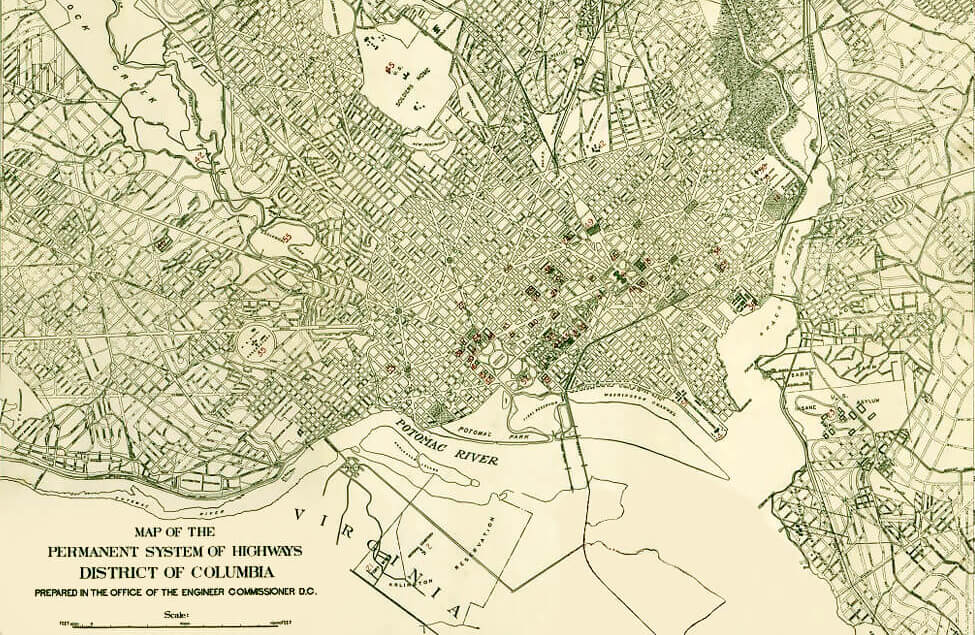
The Highway Plan: Washington’s Little-Known Planning Document
Many people are familiar with the historic L’Enfant Plan—a plan for Washington’s development, and one of the most unique master plans in the United States—and the McMillan Plan that formalized the National Mall's design. However, there is another unique plan that greatly influenced the development of Washington, DC.
During most of the 19th century, Washington developed into divided municipalities outside of the historic L’Enfant City with each maintaining its own separate government and street system. As a response to their rapid and disorganized development, Congress passed the Organic Act of 1871 which unified them into one whole District of Columbia. As an extension of the unifying Organic Act of 1871, Congress passed a law in 1893 mandating that existing streets must be changed or moved in conformity with the District’s street plan. Many property owners were upset that their private property would be seized without compensation. The Supreme Court agreed, striking down the law as unconstitutional. These “paper streets” (a street existing only on a map) were left alone for the time being.
As the city continued to develop it ran into another problem. Streets didn’t always connect naturally due to the prior development of the now unified municipalities. To address this, Congress implemented the Highway Act of 1893. Existing streets would remain, but the Highway Act mandated the implementation of a system of interconnected highways which must conform to Washington’s “official city plan” (Ellicott Plan). It's important to note the term "highway" during this time did not mean the interstate as we know it to mean today, but the primary road.
Congress ultimately transferred responsibility to implement the plan to the District government in 1914, and the National Capital Park and Planning Commission, a predecessor to NCPC, had a role in the 1920s. To oversee the intricate plan’s implementation, the District selected American landscape architect Frederick Law Olmsted and his firm (Olmsted & Associates). Olmsted proposed an extension of the L’Enfant streets from the city’s core. To preserve and mimic the surrounding landscape, he suggested more curvilinear streets in areas with challenging topography.
Many streets from the Olmsted & Associates plan were constructed, and a comprehensive Highway Plan map was regularly updated until 1968 that reflected the development and modification of the city’s freeway and street system. However, many planned streets were never developed because of constant delays in making physical improvements on proposed rights-of-way and conflicts with the existing street grid. However, these “paper streets” remained on the Highway Plan map.
Today, while most of the time little attention is paid to them, sometimes property owners request that the DC Surveyor update the Highway Plan map and remove them from the record. NCPC reviews Highway Plan map amendments when it affects federal interests; as examples, this might occur if the area in question is adjacent to a federal properties. If that is the case, NCPC will review the proposed amendment to determine if there are any negative impacts on the federal interest. Once the Commission makes a decision, it is returned to the DC Office of the Surveyor in writing and the necessary land records are updated.
While not as well-known as the L’Enfant or McMillan Plan, the Highway Plan is part of the unique Washington, DC design legacy because of its contribution to the city’s street grid we see today.