- By Stephen Staudigl
- March 16, 2018
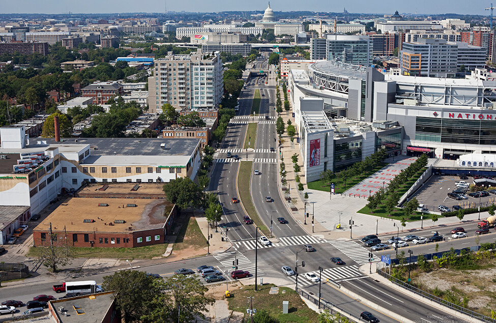
South Capitol Street’s Future Grounded in NCPC’s Planning Past
South Capitol Street, the southern axis to the United States Capitol, serves as the ceremonial entrance to the Capitol for diplomats arriving at Joint Base Andrews, and as a gateway for residents and tourists entering downtown. For too long, the one-mile stretch was a forgotten thoroughfare surrounded by industrial uses and vacant lots.
Fortunately, that is changing. This April the Commission will review the final plan for a new Frederick Douglass Memorial Bridge and early concept designs for the bridge gateways that will frame the South Capitol Street Corridor. NCPC staffer Stephen Staudigl describes how previous planning efforts set the stage for South Capitol Street’s transformation.
Planning Efforts
In Pierre L’Enfant’s plan for the nation’s capital, South Capitol Street provided the southern route to the U.S. Capitol. It did not become a gateway until bridge construction finished in 1950, connecting South Capitol Street with the Suitland Parkway, which opened in 1944. Over time the area industrialized and the corridor became a high-speed route that divided neighborhoods. By the mid 1990s, the area was home to a cement factory, oil storage tanks, and warehouses. An elevated interstate freeway (I-695) blocked the street’s views of the U.S. Capitol.
NCPC’s 1997 Legacy Plan established the first vision for the South Capitol Street Corridor. Legacy’s vision sought to transform South Capitol into a grand boulevard and a popular destination complete with magnificent spaces for public plazas, parks, national monuments, as well as commercial and residential uses.
In 2003, NCPC and the District of Columbia’s Office of Planning completed the South Capitol Street: Urban Design Study, the first of several documents that provided urban design principles and proposed scenarios to revitalize the corridor. The District Department of Transportation published the complementary South Capitol Gateway and Corridor Improvement Study that examined traffic needs and solutions for the corridor. The Anacostia Waterfront Framework Plan, a component of the Anacostia Waterfront Initiative also published in 2003, envisioned expanding connections along and across the Anacostia River.
In 2005, NCPC’s South Capitol Street Task Force proposed an urban design framework with the following key recommendations for the corridor.
To the south:
- An oval traffic rotary and a public commons where a new bridge intersects with Potomac Avenue.
- A new South Capitol Waterfront Park.
- A new mixed-use cultural development zone, with a location for a primary memorial.
- Urban development flanking a sequence of urban squares and circles and landscaped medians.
The task force proposed three flexible scenarios to bring this vision to life.
The South Capitol Street of Today
Today, the vision for the South Capitol Street Corridor is becoming a reality, as the street evolves into a boulevard worthy of its location and prominence. The last decade has seen a buzz of activity within the corridor that started with the development of the U.S. Department of Transportation headquarters and Nationals’ baseball stadium, and continues at The Yards (the former Southeast Federal Center), the Navy Yard, and the numerous new parks, office and residential buildings, restaurants, and other attractions. This summer, the new home of D.C. United will open just a short walk away.
The new Frederick Douglass Memorial Bridge at the southern end of South Capitol Street will have distinctive arches and traffic ovals with interior public spaces on both sides of the Anacostia River, referencing components of the South Capitol Street Task Force’s earlier recommendations. The bridge and ovals are designed to accommodate pedestrian and bike circulation, as well as vehicles, furthering connections across the river, and between the neighborhoods on either side of South Capitol Street.
NCPC looks forward to reviewing these plans that build upon our prior efforts to improve one of Washington’s most important corridors.
Related Resources
Please see the related resources below if you are interested in learning more about some of the studies that are behind South Capitol Street’s transformation.
South Capitol Street Urban Design Study (Jan 2003)
South Capitol Street: Grand Urban Boulevard and Waterfront Gateway (Mar 2005)
The South Capitol Gateway and Corridor Improvement Study (Sep 2003)
South Capitol Street Project Initial Financial Plan (May 2013)