- By Nick Bonard
- February 13, 2018
Understanding the New Flood Risk Guide
On January 26, NCPC and the DC Silver Jackets released the “Flood Risk Management Planning Resources for Washington, DC.” Urban Planner Nick Bonard describes why it is so important for facility managers, planners, and designers in the region to consider flood risk in their work and how this new document can help.
Washington, DC has a History of Floods
In 2006, heavy rains (six inches in five hours) over the Federal Triangle area overwhelmed the stormwater system and caused flooding in the streets and basements of multiple buildings. The result was millions of dollars of damage to federal offices and relocation of workers that lasted months during repairs. The flood also exposed the vulnerabilities of nearby museums that house priceless collections. The same flood had significant impacts on the regional transportation system, as the Washington Metropolitan Area Transit Authority shut down its Federal Triangle Metrorail Station in downtown for four days, and spent millions of dollars to clean and replace critical train control and communications equipment.
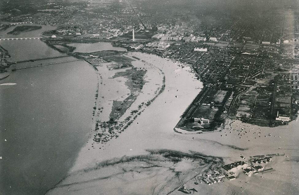
The 2006 flood was just one of many in Washington, DC’s history. Major floods in 1889, 1936 (shown in the photo, above), 1942, 1996, 2003, 2006, and 2010 all caused significant damage to buildings and infrastructure in the city. Not all floods, however, shared the same characteristics. The 2006 flood is what flood risk managers call an “interior flood,” which is a result of heavy rain and lack of stormwater sewer capacity. Most of the city’s other notable floods are either riverine floods (when heavy rains or snowmelt in the Potomac River watershed - upstream of the city - cause flooding hours or days later in Washington, DC) or coastal floods (when tropical storms or hurricanes push water up the Potomac River from the Chesapeake Bay and Atlantic Ocean).
Planning for a More Secure and Resilient Capital
Given the city’s history of flooding, addressing flood risk is an important consideration for facility managers, designers, and planners when developing a new construction project in the region. Federal asset managers must be especially aware of this risk, as many of the region’s federal properties, structures, and operations are in floodplains. Considering flood risk early on in project planning ensures that federal dollars aren’t invested in facilities easily damaged by floods, and that critical government operations aren’t interrupted if a flood does occur. In addition, facilities and investments often have lifespans of 100-plus years, so it is important to consider how flood risks at the end of the project’s life cycle may be different from today. Considering all these factors together, along with other hazards, is an important part of planning for a more secure and resilient capital.
Flood Risk Management Planning Resources for Washington, DC
The National Capital Region is fortunate to have a number of resources that can help asset managers understand flood risk. In fact, NCPC and the DC Silver Jackets identified 11 resources that are useful for this region. They include maps and visualization tools like the Flood Insurance Rate Maps, reports with information on regional flood risk like the North Atlantic Coast Comprehensive Study, and projections like the Sea Level Change Curve Calculator that predict how flood risk may be different in the future. This wealth of information, however, can be overwhelming: is not always clear what resource to use, and when.
The primary purpose of “Flood Risk Management Planning Resources for Washington, DC” is to help facility managers, planners, and designers better understand the different resources available so that they can make informed decisions on projects with flood risks. It includes a short summary of key flood risks in the National Capital Region; an overview of the 11 studies and tools that address flood risks in the region; and brief descriptions on how to best use these resources. The document also describes how flood risks may change in the future, and if the existing resources can model those future risks.
The document’s primary audience is federal and local government planners and facility managers, but anyone developing a project with flood risks in the National Capital Region can use the document. While it doesn’t provide definitive answers on a particular project’s flood risk, the document will help identify the best flood risk management resources for that project and how they should be used to guide decisions.
Learn More
Use the links below to access the full report, or watch a 10 minute presentation describing the document at NCPC’s February 1, 2018 Commission Meeting.
Read the Document Watch the Overview DC Silver Jackets Website